Türkiye'de arsa almadan önce teknik kontrolTechnical land checks before you buy in Türkiye
Harita mühendisi ve SPK lisanslı değerleme uzmanı Ömer Kaşıkcı'dan uzaktan CBS analizi, ölçekli uydu haritası ve çakışma kontrolü. Yabancı yatırımcılar ve emlak ofisleri için Türkçe ve İngilizce rapor.Remote GIS analysis, scaled satellite maps and overlap checks by Ömer Kaşıkcı, licensed surveying engineer and CMB-licensed valuation expert. Reports in English and Turkish for foreign investors and real estate offices.
Sizin sağladığınız imar planı ve kadastro verisiyle çakışma ve alan farkı analizi; Ömer Kaşıkcı'nın incelemesiyle.Overlap and area-difference analysis using the zoning plan and cadastral data you provide; reviewed by Ömer Kaşıkcı.
Proje Öncesi Arazi Ön Değerlendirme ve PlankotePre-Project Site Assessment & Topographic Plan
Yol, istinat duvarı veya bina tasarlamadan önce parselinizin teknik resmini çıkarırız: TKGM GeoJSON/KML ile parsel sınırı, Copernicus GLO-30 verisiyle eğim, kot ve bakı ön analizi, uydu altlığı ve DXF/DWG pafta. Sonuçlar Ömer Kaşıkcı'nın (HKMO 8798 · SPK 401356) imzalı ön uygunluk notuyla teslim edilir.Before you design a road, retaining wall or building, we put together a technical picture of your parcel: boundary from TKGM GeoJSON/KML, preliminary slope, elevation and aspect analysis from Copernicus GLO-30, satellite base map and a DXF/DWG sheet. Delivered with a signed preliminary suitability note by Ömer Kaşıkcı (HKMO 8798 · CMB 401356).
LiDAR, ortofoto veya nokta bulutu verisini siz ya da drone operatörünüz sağlarsanız, QGIS/PDAL ile eş yükselti eğrili plankote, kesitler ve kazı-dolgu hacim raporu da hazırlanır.If you or your drone operator supply LiDAR, orthophoto or point-cloud data, we also produce a contour plan, cross-sections and a cut-and-fill volume report with QGIS/PDAL.
Kapsam dışı: zemin etüdü, sondaj ve heyelan değerlendirmesi (jeoloji mühendisine yönlendirilir); drone/LiDAR uçuşu (şimdilik). Resmi onaylı belge değildir.Not included: geotechnical survey, drilling or landslide assessment (referred to a geological engineer); drone/LiDAR flights (for now). Not an officially certified document.
Öğrenci, Stajyer ve Yeni Başlayanlar için Harita ve Grafik Hazırlık DesteğiMap & Graphic Preparation Support for Students, Interns and Early-Career Professionals
Harita ve grafik hazırlık desteği: öğrenci, stajyer, yeni mezun veya işe yeni başlayan biri olarak ödev, bitirme projesi, staj ya da ilk iş projen için verilerini ve talebini yükle; Burdur leke paftası örneğindeki gibi paftanı hazırlayıp PDF, JPG, DXF/DWG veya GPKG olarak teslim edelim. Ücretsiz önizleme ile başlarız.Map and graphic preparation support for students, interns, recent graduates and early-career professionals: upload the data and brief for your assignment, graduation project, internship or first work project; we prepare your sheet, like our Burdur land-use (leke) sheet, and deliver PDF, JPG, DXF/DWG or GPKG. We start with a free preview.
Temel pafta (konum, parsel, uydu altlıklı): 750 TL + KDV’den (KDV dahil 900 TL’den)Basic sheet (location, parcel, satellite base): from 750 TL + VAT (900 TL incl. VAT)
Kapsamlı iş (ör. leke paftası): 3.990 TL + KDV (KDV dahil 4.788 TL) – normalde en az 5.000 TL, yeni başlayan indirimliComprehensive work (e.g. land-use sheet): 3,990 TL + VAT (4,788 TL incl. VAT) – normally 5,000 TL+, early-career discount
1 revizyon turu dahil (teslimden sonra 7 gün); ek revizyon basit 250 TL, kapsamlı 750 TL + KDV1 revision round included (within 7 days of delivery); extra revision 250 TL simple, 750 TL comprehensive + VAT
Sunulmayan: resmi imzalı/mühürlü harita, tapu-kadastro belgesi, imar durumu, .mxd/.aprx veya Civil 3D proje dosyası, fotogrametri/drone işleme, 3B model, kullanıcının kendi işi gibi sunulacak rapor yazımı.Not offered: officially signed/sealed maps, title/cadastre documents, zoning status, .mxd/.aprx or Civil 3D project files, photogrammetry/drone processing, 3D models, report writing to be submitted as the user’s own work.
Hazırlanan harita bilgi amaçlıdır; tez, ödev ve projede kullanımına ilişkin akademik etik ve kaynak gösterme sorumluluğu kullanıcıya aittir.Maps are provided for information; academic integrity and proper citation when using them in theses, assignments or projects are the user’s responsibility.
TeslimDelivery
Basit pafta 1–3 saat · leke paftası 1–2 gün · çok paftalı set 3–5 gün (veri eksiksiz gelince)Simple sheet 1–3 h · land-use sheet 1–2 days · multi-sheet set 3–5 days (once data is complete)
Sunulmayan: drone uçuşu ve ham drone görüntüsü işleme, resmi onaylı belge, TKGM/e-Devlet sorgusu. Kadastro ve imar verisini müşteri sağlar.Not offered: drone flights and raw drone image processing, officially certified documents, land registry (TKGM) queries. Cadastral and zoning data are supplied by the client.
Nasıl çalışır?How it works
Konum veya parsel bilgisini ve varsa belgeleri gönderin.Send the location or parcel details and any documents.
Kapsam ve fiyat teklifini alın.Receive a scope and quote.
Analiz yapılır, Ömer Kaşıkcı inceler.We analyse; Ömer Kaşıkcı reviews.
PDF/DXF teslim ve kısa açıklama.PDF/DXF delivery with a short walkthrough.
Örnek ÇıktıSample Output
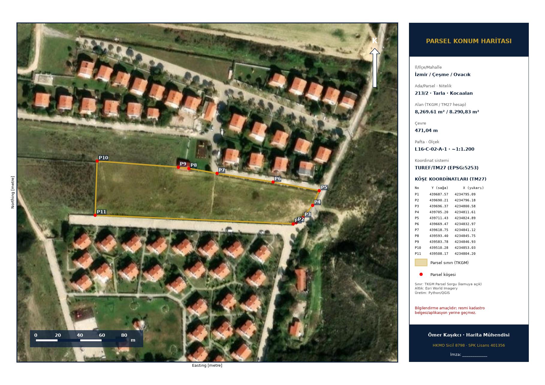
Örnek: Çeşme / Ovacık 213 ada 2 parsel (Tarla, 8.269,61 m²). Sınır TKGM verisinden (GeoJSON/KML); köşe koordinatları TUREF/TM27, ölçek, lejant, kuzey oku. KML, DXF, DWG ve kot/eğim çıktısı dahil.Sample: Çeşme / Ovacık block 213 parcel 2 (field, 8,269.61 m²). Boundary from TKGM data (GeoJSON/KML); corner coordinates in TUREF/TM27, scale, legend, north arrow. KML, DXF, DWG and elevation/slope outputs included.
Rapor resmi belge yerine geçer mi?Is the report an official document?
Hayır. Raporlar bilgilendirme amaçlıdır, resmi belge yerine geçmez. Resmi işlemler için ilgili kurumlardan belge alınmalıdır.No. Reports are for information only and do not replace official documents. Obtain official records from the relevant authorities.
Sahaya geliyor musunuz?Do you visit the site?
Hizmetler uzaktan, kamuya açık uydu ve harita verisi ile sizin sağladığınız belgelerle yapılır.Services are remote, using public satellite and map data plus the documents you provide.
Hangi verileri göndermeliyim?What data should I send?
Konum/koordinat, varsa tapu-kadastro çıktısı, imar planı ve DXF/DWG dosyaları.Location/coordinates and, if available, title/cadastral printouts, zoning plan and DXF/DWG files.
Fiyatlar nasıl belirleniyor?How is pricing set?
Paket fiyatları başlangıç fiyatıdır; büyük alan veya ek kapsam için teklif verilir. Fiyatlara %20 KDV eklenir.Package prices are starting prices; larger areas or extra scope are quoted. 20% VAT is added.
Hangi dillerde rapor alabilirim?Which languages?
Türkçe ve İngilizce.English and Turkish.
Yeni başlayanlar paketinde kaç revizyon hakkım var?How many revisions does the early-career package include?
1 revizyon turu dahildir (aynı kapsamda yazım, renk, etiket, lejant, ince ayar), teslimden sonra 7 gün içinde. Ek revizyon basit 250 TL, kapsamlı 750 TL + KDV. Sınır, altlık veya zon kurgusu değişirse yeni iş sayılır.One revision round is included (text, colours, labels, legend, fine-tuning within the same scope) within 7 days of delivery. Extra revisions: 250 TL simple, 750 TL comprehensive + VAT. Changes to boundary, base data or zoning layout count as a new job.
İndirim için belge gerekiyor mu?Do I need proof of eligibility?
Öğrenci belgesi, staj yazısı, iş yeri bilgisi veya kimlik istenebilir.A student certificate, internship letter, employer details or ID may be requested.
Pafta ne kadar sürede teslim edilir?How long does a sheet take?
Veri eksiksiz geldiğinde: basit pafta 1–3 saat, leke paftası 1–2 gün, çok paftalı set 3–5 gün. Eksik/hatalı veride süre başlamaz.Once data is complete: simple sheet 1–3 hours, land-use sheet 1–2 days, multi-sheet set 3–5 days. The clock does not start with missing/faulty data.
Hazırlanan haritayı tezimde, ödevimde veya iş projemde kullanabilir miyim?Can I use the map in my thesis, assignment or work project?
Harita bilgi amaçlıdır. Akademik etik, kaynak gösterme ve kurum kurallarına uyum sorumluluğu kullanıcıya aittir.The map is for information. Academic integrity, citation and compliance with your institution’s rules are your responsibility.
Projeni YükleUpload Your Project
Verilerini ve talebini e-postayla gönder, ücretsiz önizleme ve fiyatı e-postayla bildirelim. Tüm alanlar zorunludur.Email us your data and brief; we’ll email a free preview and price. All fields are required.
Hazırlanan harita bilgi amaçlıdır; akademik etik sorumluluğu kullanıcıya aittir.Maps are for information; academic integrity is the user’s responsibility.